Geology - Plate Tectonics
Geology - Plate Tectonics
"...And yet it [Earth] does move."
~ Galileo
Image: USGS
We first looked at geology with regards to time. Now we are going to look at one of the driving forces behind the Earth’s geologic processes. The theory of plate tectonics has been widely accepted for the last forty years, but it has taken about sixty years for the pieces of this grand puzzle to fall (or rather move) into place.
We will begin our discovery of plate tectonics by first studying who, through the years, has contributed to the theory that we now know as plate tectonics.
We will then examine background information to enhance our understanding of plate tectonics and the mechanisms that drive this enormous and ancient process.
Guiding Questions
- The Theory of Plate Tectonics is considered the unifying theory in Geology, if so, then how did it come about and who helped to develop this cornerstone theory?
- What is a tectonic plate?
- How does a tectonic plate move?
- What happens when a tectonic plate moves and interacts with other tectonic plates?
- What visual Earth features and/or catastrophic events occur when a tectonic plate(s) move?
- Where were the continental plates during various eons, epochs and periods of Earth’s history?
Origin of the Theory
The processes, their discovery and the formation of the plate tectonics theory has involved several individuals over the course of the last century and resulted in the development of a theory that optimizes the term ‘multidisciplinary’.
We will start by reading the following articles that outline the contributions of Alfred Wagener. The first article comes from the University of California Museum of Paleontology (again).
- Follow this LINKto the home page of the “Tour of Geologic Time”
- Click the LINK on this page titled “Visit our exhibit on plate tectonics...”
- Please read the article “The History Behind Plate Tectonics”
The second article comes from a USGS publication called “This Dynamic Earth”.
This Dynamic Earth – Online version Instructions:
- Follow the LINK to “THIS DYNAMIC EARTH”
- Choose the image/link at the bottom entitled “Preface”
- Read the “Preface” page and continue through the “Historical Perspective” page.
- Stop at the sidebar at the end of the "Historical Perspective" page.
The images within the on-line version are ‘clickable'!
Earth’s Structure, Convection Cells, and Tectonic Plates
These three topics provide some necessary background information to explain why and how the tectonic plates of the Earth move. To explore these topics in more detail we will be using a USGS Publication and a web-site sponsored by the University of California at San Diego.
Earth’s Structure
USGS Publication: This Dynamic Earth – On-line version instructions:
- Use this LINK and go the web-site titled “THIS DYNAMIC EARTH”
- Choose the image/link at the bottom titled “Historical Perspective”
- Scroll to the bottom, find the ‘sidebar’ and choose the image/link titled “Inside Earth”
- Go to this page and read it.
UCSD sponsored web-site:
- Use this LINK
- Read through the overview of the web-site so you have a better understanding about how to navigate this site.
- Choose the button/link at the top of the page titled “Earth Layers” or you can use this LINK.
- Go to the bottom of the page and view the three animations (top to bottom).
Convection Cells
Convection cells propel numerous natural processes and therefore occur across many natural systems on earth. Regarding plate tectonics, convection cells within the earth’s mantle are produced by two factors. We will use the USGS publication and web-site from the UCSD.
USGS Publication--On-line version Instructions:
- Use this LINK and read the section titled “WHAT DRIVES THE PLATES”
- You do NOT need to read the section entitled “Extraterrestrial Plate Tectonics”
Note:
We will discuss some of the people mentioned in these readings later.
UCSD web-site:
- Use this LINK and read the article number six on the page that is titled "Mechanisms for Plate Movement" which is the last article on the page. When you have completed reading it, view the animation.
More Information
Use this LINK to view another description and associated image about the process of convections within the mantle and how they move tectonic plates.
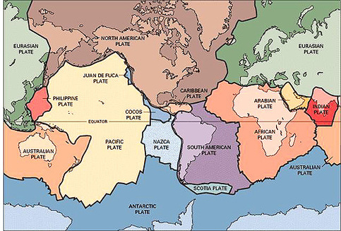
What is a tectonic plate?
The at the bottom of the page, which was created by the USGS, shows the tectonic plates. As you can see, tectonic plates are more than just the continents, so the question is, “What is a tectonic plate?"
USGS Publication - This Dynamic Earth – On-line version instructions:
- Use this LINK and go to “This Dynamic Earth”
- Choose the image/link at the bottom titled “Historical Perspective”
- Scroll to the bottom, find the ‘sidebar’ and choose the image/link titled “What is a Tectonic Plate?”
- Read the article "What is a Tectonic Plate?"
UCSD sponsored web-site:
- The FIRST IMAGE shows the continents, their plates,and the boundaries of the plates. (We will investigate the boundary regions of tectonic plates later.)
- The SECOND IMAGE is similar to the image posted on this page.
The Whole Theory
We are now ready to see how the remaining pieces of the plate tectonic theory fell into place.
USGS Publication -- On-line Instructions:
- Follow this LINK to "This Dynamic Earth".
- Select the image/link at the bottom of the page titled “Developing the Theory”.
- Please read this entire section.
The Movement
The movement of the continents has been suspected and accepted by mankind for over 150 years. The detailed understanding of the whole process, on the other hand, is still evolving. The information provided thus far has explained how the theory of plate tectonics was a work in progress for about a century.
Scientists have discovered that the regions on Earth where tectonic plates meet, their boundaries, are also where a majority of the geologic activity on Earth occurs. The boundaries of the tectonic plates therefore are an incredible source of information for geologists to further their understanding and at times discover new aspects of the Earth’s tectonic plate system.
We have provided the information below from several sources that will explain the types of boundaries that form between tectonic plates.
USGS Publication-On-line Version Instructions:
- Use this LINK and go to "This Dynamic Earth".
- Use the image/link at the bottom of the page titled“Understanding Plate Motions”
- Read this entire section please.
More Information
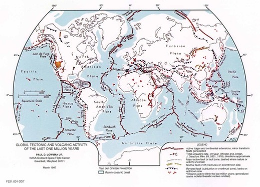
Use the two map links below to gain a better understanding of where the three types of tectonic plate boundaries form. (Convergent, Divergent and Transform)
- The FIRST MAP is provided by the USGS. Please read the narrative that explains where the three types of boundaries occur.
- The SECOND MAP is from the UCSD web-site that we have been using. Look over the map first without turning on any of the interactive portions. Then start at the top of the interactive key and turn on and off each of the four boundaries that this map shows.
Clarification
A diffuse boundary (the fourth boundary area on the second map) occurs when weakened plates meet. What is happening at these boundary areas is still being determined. What seems to be happening is that the plates at diffuse boundary areas are diffusing or weakening sooner (with regards to distance from crustal surface) than ‘normal’ convergent boundary areas. Scientists feel that this discovery has shifted “…modern geoscience to advance from a kinematic plate tectonics theory towards a more integrated understanding of the dynamics of the Earth system. [Molnar 1988 and Liu 2001].” This LINK is to the entire paper published by Dr. Mian Liu, from the University of Missouri.
The Evidence is Here Today!!!
The three types of tectonic plate boundaries form all over the world and interact to produce significant geologic features and events. We will now learn about some of these features and events by examining three recent examples that occur along tectonic plate boundaries.
Sea Floor Spreading
Sea Floor spreading was first proposed by Captain Harry Hammond Hess. Through his work while in the navy, scientists have been able to understand the significance of the location of ‘new’ sea floor crust and the boundaries of tectonic plates.
USGS Publication - On-line version instructions:
- Use this LINK and read the whole article.
The Lost City
The “Lost City” was discovered in 2000 by scientists from the University of Washington. This “Lost City” is a biological and geological marvel. We will now explore the “Lost City” using a NOAA sponsored web-site called OCEAN EXPLORER.
- Use this LINK and read the mission summary page for the “Lost City” expedition launch in 2005, and read the page. Once you have read through the text on this page, please click the textual link “Lost city hydrothermal field”, to get an appreciation for where the Lost City is located.
- Use this LINK and read the mission plan page for the “Lost City”expedition.
- Use this LINK and read the mission overview page of the “Lost City”expedition.
- Now go back to the top of the page and go back through the page clicking on all the textual images and read the corresponding pages that appear.
- Now find the embedded textual link “surrounding sea floor” and click. Read the entire article that appears, “Descent to Mid-Atlantic Ridge”.
- Use this LINK and read the serpentinization page of the “Lost City” expedition.
The “Lost City” represents a location on Earth that validates the sea floor spreading theory. It is not the only one, but is one of the most recently discovered locations. The sea floor crust that is located at this site is very young, only a million years old. The interaction of the biotic, marine and tectonic systems creates a truly unique and diverse community hundreds of meters below the surface of the Atlantic Ocean, truly a “Lost City”.
We hope you enjoyed your expedition to the “Lost City”, but before we conclude, we have provided two more links that have numerous images for you to view.
More Information
The PHOTO AND VIDEO LOG has numerous images from the “Lost City” expedition. The GALLERY LINK will take you to the gallery for the entire Ocean Explorer web-site, and of course has numerous images, videos and maps.
Earthquakes-- San Francisco Earthquake of 1906
Earthquakes have been shaking the Earth for eons, and are a result of the release of energy from within the earth as tectonic plates collide, glide, and slip across one other, which usually occurs at a boundary area or a fault. One very recent example is the San Francisco Earthquake of 1906. We will use this actual event to look at the mechanics of an earthquake.
- Use the following LINK to learn about the San Francisco Earthquake of 1906 Start your learning by reading the introduction.
- Proceed through the rest of the site by following the topical links on the left side of the page.
- When you reach the “Casualties” page read the “Official Account…” at the bottom of the page.
For Your Information
You can find an explanation of the MMI scale by at this web-site.
More Information
Use this LINK to go the USGS Earthquake Hazards site. Once at the site click on the map entitled “USA Magnitude +1” When you click on the colored squares you can see location of the most recent earthquake activity in the United States.
Volcanoes—Mount St. Helens
The eruption of Mt. Saint Helens in May of 1980 was not a surprising event for geologists, but it still provided a “powerful” event to learn more about how volcanoes work. When we examine where this volcano is located in light of the material we are studying we should not be surprised either. Mount. St. Helens is located in Washington State, but more germane to our subject matter is the location of Mount St. Helens is within the region on the Earth that has been named the “RING OF FIRE” .
- Please follow this LINK to the Mount Saint Helens site prepared by the USGS
- There are a total of thirteen sections that provide information about Mount Saint Helens, and we will be going through the first ten sections in order. The remaining three sections are optional.
- Use this LINK to examine the present day status of Mount St. Helens. Choose the introduction link on the page.
Note
The narrative found in the introduction corresponds to the 11X17 lithograph that we printed for you. We feel that the Mount St. Helens information and the lithograph provide a very detailed and visual understanding of the processes that drive a volcano.
More Additional Information
An undersea volcano errupted in October of 2005. Here are the satellite images, eyewitness account and a list of recent volcanic activity.
Geologic Time Scales and Plate Tectonics
The last connection, which we have already covered to some degree, is between geologic time scales and the theory of plate tectonics. We will now examine the location of the continents throughout the 4.5 billion year history of earth, and the evidence that has led scientists to understand the processes at work with regards to the movement of the continents.
The PALEOMAP PROJECT is the first web-site that we will be using.
- Use this LINK and go to "The Paleomap Project"
- Select “Animations” along the left side of the page.
- Scroll down the page to the “Continental Drift Animations”
- Proceed through the list of “Continental Drift Animations”
- Scroll up the page to the “Paleoglobe Animations” and proceed through the list
THIS DYNAMIC PLANET is the second web-site that we will be using. This is a web-site that is a cooperative creation of the Smithsonian Institute, the USGS, and the U.S. Naval Research Laboratory.
- Use this LINK to go to the web-site "This Dynamic Planet"
- Scroll down the page and click on the image that says “Back of Map”
- Scroll to the bottom of the page and click on the “Timeline”
- The controls for this page/image are at the bottom.
A Picture is Worth a Thousand Words
Plate Tectonics
The Dynamic Earth - Created by the Smithsonian Institution. Provides a visual overview of the geologic processes that are responsible for the moving the tectonic plates. Slideshow- Animations Video - Proceed to the Plate Tectonic Section
Wegener-Continetial Drift Created by Declan DePaor. Presents a view of the contintents at the level of map precession available to Alfred Wegener Animation
Bullard fit of Continents Created by Decland Depor. Demostrates how the continents are believed to fit together. Animation
Plate Boundaries
Basic Plate Boundaries Created by Stephen Marshak. Shows the three types of tectonic plate boundary areas. Animation
Sea Floor Spreading
Magnetic Reversals. Demonstrates how the sea-floor anomaly of magnetic stripes occurs. Animation
Sea Floor Spreading Created by Declan DePaor. Shows the progressive stages in the opening of the Atlantic Ocean. Animation
Ocean Crust
Formation of Ocean Crust Created by Stephen Marshak. Demonstrates how ocean crust forms above a steady-state magma chamber Animation
Faults
Types of Faults Created by Stephen Marshak. Demonstrates the differneces between the three types of faults Animation
Seismagraph
Seismic Wave Motion Created by Stephen Marshak. Demonstrates how seismologists distinguish between different types of seismic waves Animation
How a Seismograph Works Created by Stephen Marshak. Shows how a seismograph works Animation
Volcanoes
Hot Spot Volcanoes Created by Stephen Marshak. Demonstrates how hot spot volcanoes form Animation
Mountain Building
The Southern Appalachians: A Changing World Created by the USGS. Describes the geology of the Southern Appalachian Mountains and the geologic events responsible for thier formation Video (@25min.)
History of Plate Tectonics
Birth of a Theory Earth Revealed video series. Traces the development of the theory of plate tectonics video (@30 min) Select Title From Page
Movement of Tectonic Plates
Plate Dynamics Earth Revealed video series. Examines the movement of tectonic plates and the results of these interactions Video
(@30min.) Select Title From Page
Sea Floor
The Sea Floor Earth Revealed video series Looks at the methods used to study the sea floor Video (@30min.) Select Title From Page
At This Point - Proceed to the next subtopic: AP Notes - Earth Structure